The TRAILFINDER is a company specializing in the pinpointing of historic pioneer trails, foundations or outlines of buildings, graves, Indian trails and Indian sites or other long-lost traces of civilization.
Using a combination of the ancient art of Dowsing (water-witching) and modern technology, The TRAILFINDER can locate trails and other sites with a high degree of accuracy. This often means both wheel tracks of wagon wheels, and within inches of the actual location. This also means finding these sites in places with no evidence of ruts, such as fields farmed over for 130 years.
|
|
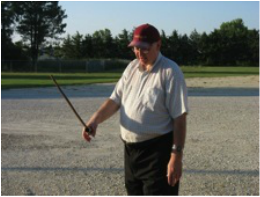
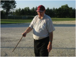
Brian Stucky demonstrating his dowsing method, holding his L-shaped copper pipe at an upward angle (left) just barely tight enough to not let natural gravity pull it down; and (right) as he walks over a target of disrupted earth, the rod rotates and pulls downward.
The TRAILFINDER has pinpointed spots on the Chisholm Trail, Santa Fe Trail, Oregon Trail, Cherokee Trail, the exact sites of the Stone Corral, Fuller’s Ranch, French Frank’s Trading Post, and Lost Springs Station on the Santa Fe Trail, and many other lesser known trails and sites. In addition, he has identified and confirmed surveyed locations of Indian trails such as the Kaw Indian Trail and Osage Trail. He is currently researching and mapping Pioneer and Indian Trails in Central Kansas for a possible future book.
He has also dowsed and mapped Indian sites, finding spots for cache (storage) pits, post locations, and earthlodge patterns. In Spring of 2008 he worked in accordance with the Kansas State Historical Society to dowse and map at the Pawnee Indian Village, Republic, KS, before the annual Kansas Archaeology Training School. Comparison of dowsing results to the actual achaeological excavation findings are inconclusive, as the 2008 excavation did not go deep enough to find post hole patterns, according to State Archeologist Robert Hoard.
He has also dowsed and mapped Indian sites, finding spots for cache (storage) pits, post locations, and earthlodge patterns. In Spring of 2008 he worked in accordance with the Kansas State Historical Society to dowse and map at the Pawnee Indian Village, Republic, KS, before the annual Kansas Archaeology Training School. Comparison of dowsing results to the actual achaeological excavation findings are inconclusive, as the 2008 excavation did not go deep enough to find post hole patterns, according to State Archeologist Robert Hoard.
He has also located graves and burial places in over 30 cemeteries in Kansas, both independently and as part of
location and identification projects for local museums.
Following, measuring and documenting trails over hundreds of miles in central Kansas, The TRAILFINDERis excited to help discover and map trails for others.
location and identification projects for local museums.
Following, measuring and documenting trails over hundreds of miles in central Kansas, The TRAILFINDERis excited to help discover and map trails for others.
|
|
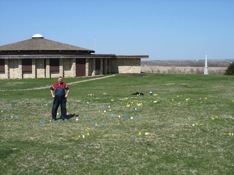
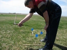
Brian Stucky dowsing the site of an Indian earthlodge at the Pawnee Indian Village, Republic, KS in May 2008. He was able to determine and map inner and outer post circles and the center hearth, or fire pit. Circles of various sizes were flagged and mapped using the Kansas State Historical Society’s grid system. The Kansas Anthropological Association and the KSHS sponsored the archaeological dig that followed.
BRIAN D. STUCKY was raised on a farm in western Harvey County, KS, on the Little Arkansas River, an area rich with Indian sites. He is a graduate of Moundridge High School and Bethel College (1975.) He is retired from teaching Art and Photography for 38 years, 34 of those at Goessel High School. He has a wide variety of interests, including church, writing, and historical interests. He is the author of “Hallowed Hardwood, the Vintage Basketball Gyms of Kansas” first published 2003 and distributed statewide.
